


When preparing, implementing or maintaining a Security Plan or other defence strategy such as is required for ISPS International Ship & Port Facility Security Code Compliance, a clear awareness of the spatial characteristics of the area layout, its buildings, facilities, security risks and threats is vital.
At the scene of an actual terrorist or other attack clear spatial data
of the area is even more essential and urgent.
"Where there is shared situational awareness of spatial data, awareness of the overall picture, awareness of observation points, awareness of hidden features, awareness of possible future developments during an incident and awareness of response options, then there is information dominance."
Less than 2% of the general population can adequately comprehend technical drawings and maps. Fewer still can quickly construct a satisfactory mental model of the scene from such data. Many pretend to have such skills.
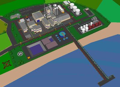
The content of Emergency Risk Mapping 3D area models is far more readily accepted by our visual senses and is more compatible with our brain¹s spatial data processing mechanisms.
Spatial information when presented in 3D is less prone to being misunderstood, is processed more rapidly and is remembered more clearly.
Computer technology now makes it possible to have an interactive 3D model specifically tailored for Risk Management and Incident Response. Such 3D site or building models may be manipulated rapidly on-screen with minimal computer skills and without the need for technical drawing experience.
Please see example in drawing below and for more information contact me.